

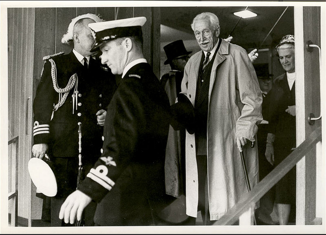
Fort Willam au temps de la Compagnie du Nord-Ouest en 1811, date inconnue, Lieutenant Irvine, Archives de la Ville de Thunder Bay, 1990-17 #54.
Courtoisie des Archives de la Ville de Thunder Bay.

Fort Willam au temps de la Compagnie du Nord-Ouest en 1811, date inconnue, Lieutenant Irvine, Archives de la Ville de Thunder Bay, 1990-17 #54.
Courtoisie des Archives de la Ville de Thunder Bay.
Fort William in the days of the Northwest Company, 1811, Date Unknown, Lieutenant Irvine, City of Thunder Bay Archives, 1990-17 #54.
Courtesy of the City of Thunder Bay Archives.
Le Fort William, centre opérationnel de la Compagnie du Nord-Ouest entre 1803 et 1821, constitue une plaque tournante dans l’histoire du Canada. À compter de 1971, il a été fidèlement reconstruit comme site historique, à 15 km de son emplacement originel à l’embouchure de la rivière Kaministiquia, sur la rive nord du lac Supérieur. Fort William est un lieu de passage majeur à bien des égards. Aux XVIIIe et XIXe siècles, il servait de point de rencontre entre l’est et l’ouest du continent dans l’importante industrie de la fourrure à l’ouest des Grands Lacs. Aujourd’hui, il joue encore ce rôle, mais entre les dizaines de milliers de visiteurs contemporains qui fréquentent ce site chaque année et les personnages autochtones, canadiens-français et écossais de cette époque charnière de l’histoire canadienne.
Le Fort William d’aujourd’hui, tout comme le tout premier érigé en 1803, est situé à un endroit différent de celui où il se trouvait à l’origine. Il faut remonter au début du XVIIIe siècle pour comprendre la raison d’être de cet établissement. À l’époque, la quête des fourrures devenues plus rares dans l’est du continent pousse les Français à s’aventurer progressivement vers l’ouest et le nord. Dès 1717, Zacharie de la Noue fonde le fort « Camanitigoya » sur la rivière Kaministiquia près de l’actuelle ville de Thunder Bay *, dans le but d’étendre la traite des fourrures vers l’ouest. Il veut aussi inciter les autochtones à cesser d’apporter leurs fourrures aux postes de la Compagnie de la Baie d’Hudson établis au bord de la baie James et de la baie d’Hudson depuis 1670. Or, la route d’eau qui conduit du fort « Camanitigoya » au lac Winnipeg et au bassin hydrographique de tout le nord-ouest canadien comporte de nombreux portages. Les autochtones montrent alors aux Français une autre route, celle de la rivière Pigeon, située plus au sud. Elle a l’avantage d’être plus courte, et ne comprend qu’un « Grand portage » d’environ 14,5 km. À compter de 1731, le fort de la rivière Kaministiquia est donc progressivement délaissé en faveur de Grand Portage, qui demeure la voie commerciale privilégiée pendant plusieurs décennies. Sous le régime anglais, de nouvelles entreprises de traite des fourrures voient le jour, notamment la Compagnie du Nord-Ouest (CNO) en 1779.
En 1778, Peter Pond, avec l’appui de la CNO, parvient au lac Athabasca, où il découvre un territoire encore très riche en castors : il devient ainsi le premier Européen à se rendre aussi loin au nord-ouest du continent (à la limite septentrionale de l’actuelle province de l’Alberta). Or, vu les 5 000 km qui séparent Montréal de cette région, il est impossible d’effectuer le trajet en canot en un seul été. La solution qui s’impose est de créer un entrepôt à mi-chemin, où les fourrures du nord peuvent être transbordées dans des canots chargés de marchandises de traite en provenance de Montréal. Grand Portage est choisi comme lieu d’échange. À partir de là, les canots qui repartent vers le nord-ouest sont chargés de marchandises de traite. Ceux qui retournent à Montréal rapportent des fourrures.
Cependant, en 1794, dans la foulée de la guerre d’indépendance américaine, le Traité de Jay délimite la frontière entre les États-Unis et le territoire britannique. Grand Portage se retrouve alors en sol américain. Pour éviter de payer des frais de douane sur ses marchandises, la CNO « redécouvre » la route de la rivière Kaministiquia et, en 1803, relocalise ses opérations près du site de l’ancien fort français.
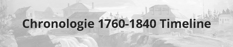
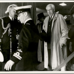
Le fort reprend le nom Kaministiquia et finit par compter une quarantaine d’édifices sur 25 acres (10 hectares). Plus qu’un simple comptoir, il renferme des magasins, un grand hall, des logements pour les bourgeois, c’est-à-dire les dirigeants de la CNO, des ateliers pour les divers artisans et pour réparer des canots et des bateaux, des greniers, des entrepôts, des bureaux et même une prison. Ces édifices font tous partie du site reconstruit. En plus de servir d’entrepôt et de lieu de rencontre entre les canots venus du nord-ouest et ceux venus de Montréal, le fort accueille les partenaires de la CNO qui y tiennent leur réunion annuelle. Au cours de la réunion de l’été 1807, ceux-ci rebaptisent l’établissement Fort William en l’honneur de William McGillivray, qui remplace son oncle décédé, Simon McTavish, comme figure dominante de l’entreprise. […]
Fort William, the operations base of the North West Company from 1803 to 1821, marks a milestone in the history of Canada. Starting in 1971, the fort was faithfully reconstructed as a historical site some 15 km from its original location at the mouth of the Kaministiquia River, on the north shore of Lake Superior. Fort William is a significant location in many respects. During the 18th and 19th centuries, it played a crucial role in the fur trade west of the Great Lakes, a major industry at that time, by serving as a meeting place linking the eastern and western parts of the continent. Today, it is still a meeting place, but now it connects the tens of thousands of visitors who flock to the site every year with the experience of the First Nations, French-Canadian, and Scottish people who were the key players in the story of this important turning point in Canadian history.
Today’s Fort William, resembling the original one constructed in 1803, is in a different location than where it first stood. The reasons for the fort’s existence stretch back to the beginning of the 18th century. At that time, in the search for furs that have become increasingly rare in the eastern part of the continent, the French venture progressively further west and north. As early as 1717, Zacharie de la Noue establishes Fort “Camanitigoyaˮ on the Kaministiquia River, close to where the present-day City of Thunder Bay is located *, with the goal of extending the fur trade towards the west. He also seeks to encourage the First Nations people to trade with the French instead of taking their furs to the Hudson’s Bay trading posts established on the shores of James Bay and Hudson’s Bay since 1670. However, the many portages impede travel on the water highway that links Fort “Camanitigoyaˮ to Lake Winnipeg and the river basin for the entire Canadian Northwest. The First Nations people show the French another route, following the Pigeon River, located to the south. This route, which has the advantage of being shorter, has only one long “grand portageˮ that stretches over 14.5 km. Thus, beginning in 1731, the Kaministiquia River fort is gradually abandoned in favour of the Grand Portage route, which becomes the preferred commercial route for several decades. With the beginning of the British regime, new fur companies are established, notably the North West Company (NWC) in 1779.
In 1778, Peter Pond, with the support of the NWC, reaches Lake Athabasca, where he discovers a territory still rich in beaver pelts. He becomes the first European to venture so far into the northwestern part of the continent (the area corresponding to the present-day northern border of the Province of Alberta). However, since this area is 5,000 km from Montreal, it is impossible to make this journey by canoe in a single summer. The obvious solution is to set up a warehouse at the halfway point where furs gathered in the North can be loaded into canoes arriving with trade goods shipped from Montreal. Grand Portage is chosen to be this transfer point. After the exchange, the canoes from the Northwest return loaded with trade goods, while those that make the return trip to Montreal carry the pelts.
In 1794, as a result of the American War of Independence, the Jay Treaty establishes a new border between the United States and the British territory. As a result, Grand Portage finds itself on American soil. In order to avoid paying duty on its merchandise, the NWC “rediscoversˮ the Kaministiquia route and, in 1803, relocates its trade operations near the site of the old French fort.
The fort revives the name Kaministiquia and, over time, comes to include some forty buildings erected on 25 acres (10 hectares). More than just a simple trading post, the fort contains storehouses, a great hall, residences for the bourgeois, that is to say, the managers of the NWC, workshops for various artisans and for repairing canoes and boats, granaries, warehouses, offices, and even a jail. These buildings are all part of the reconstructed historical site. As well as serving as a warehouse and meeting place for the canoes arriving from the Northwest and those coming from Montreal, the fort also welcomed the partners of the NWC who would hold their annual meetings there. During the summer meeting of 1807, the partners vote to rename their headquarters Fort William in honour of William McGillivray, who had replaced his deceased uncle, Simon McTavish, as the leading figure of the NWC. […]
Encyclopédie du patrimoine culturel de l’Amérique française, 2007:
Extrait de l’article « Fort William, plaque tournante de la traite des fourrures » par Daniel Marchildon
Source
* Pour plus d’informations sur les sources citées dans cet article / For more information about the sources cited in this article:
Source
Les Archives de la Ville de Thunder Bay assurent la préservation, la promotion et l’accessibilité publique de l’histoire des entreprises de Thunder Bay, et ce selon les contrôles et normes de gestion de documents établis par le Conseil canadien des archives.
City of Thunder Bay Archives
The City of Thunder Bay Archives preserves, promotes, and makes public the City’s corporate history by managing documents through systematic records management controls and standards established by the Canadian Council of Archives.
Info: 35 Vickers Street N., Thunder Bay P7E 5V3
Tel: 807-625-2270
www.thunderbay.ca